martes, 13 de noviembre de 2012

Climate

La Fortuna is located 10 dregrees North of the equator receiving an average of  12 hours of  sunlight every day. Year round the amount of sunlight received is 12 hours and during summer the amount of sunlight is reduced by less than a half hour.


Due to the amount of sunlight received the climate is warm and there are minimum changes of temperatures during the year.

According to Koeppen-Geiger Climate Classification Scale
 La Fortuna has a climate of Af- Tropical Wet Rainforest
A: Tropical Humid at low latitudes; warm and wet f: wet all year
This scale does not take in consideration cloud coverage, winds or sunshine.

SOURCE


 Seasons
Seasons are caused by the tilt (23.5 degrees) of the earth 
                                                          La Fortuna has two seasons
Rainy Season: Winter from June-November
Dry Season: Summer from December-May

The two seasons mark the amount of precipitation received not the change in temperatures since they remain almost constant with a minimum increase in the dry season.

As it can be observed in the above Average Temperature chart, temperatures have a small change during the two seasons. Such as in summer where there is less precipitation there are slightly higher temperatures and low temperatures remain the same throughout the year.


During the rainy season, rain is expected in the form of thunderstorm or torrential downpour in  the afternoon or evening


SOURCE


 SOURCE


2nd Law of Geography: Land cools and heats faster than water
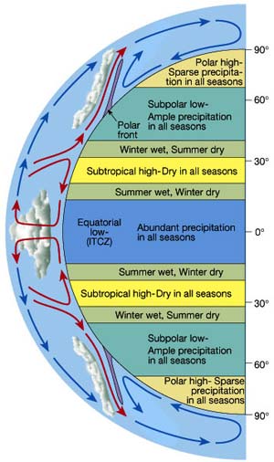
As land starts to cool, warm air (low pressure) starts to rise expanding and cooling, the Pacific ocean cool air (high pressure) starts to move inland helping lift  low pressure. Pressure always moves from High pressure to Low pressure because high pressure in denser than low pressure. Also warm air has a greater potential to hold more vapor water when it cools it causes precipitation.


Rainfall is influence by the ITCZ (Intertropical Convergence Zone) a low pressure system that migrates North and South depending on season. When the ITCZ moves north the Coriolis effect deflects the trade winds to the right making September and October the rainiest months.
Also the Northeasterly winds knows as Trade winds also affect rainfall by carrying moisture.

jueves, 11 de octubre de 2012

Hydrology

Costa Rica is located at the tropics surrounded by water. The climate is humid and high amounts of rain during May-November. Through out Costa Rica there are different types of water bodies  represented as underground water and surface water. It has a transboundary aquifer the Lower and Upper Colima located in the Central Valley of Costa Rica shared with Nicaragua.

            http://aquadoc.typepad.com/.a/6a00d8341bf80a53ef0120a645e035970b-320wi

Even though La Fortuna is a small town it also contains bodies of water represented as waterfalls, hotsprings, lakes and caves. La Fortuna attractions are part of the hydrology system created thousand of years ago. This internationl attractions have been adapted by citizens and travelers for daily life needs such as producing
energy and others for relaxing, enjoying nature and its health benefits.

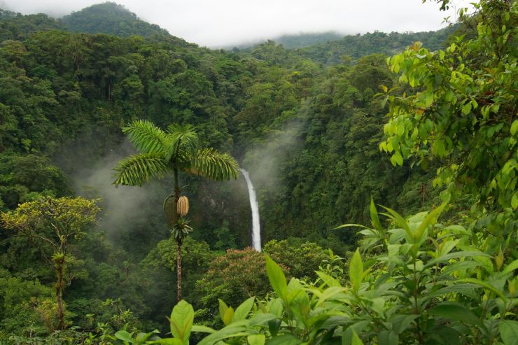
La Fortuna Waterfalls


The waterfall was created by a lava flow of Chato Volcano now inactive and feed by the River Celeste.The bright color is due to the high amounts of minerals contain in the water provided by the Tenorio Volcano.


                                           Hot Springs


Feed by ground water heated by the hot rocks interacting with magma. Volcanic eruptions have form permeable layers with lava and with high amounts of rainfalls have created aquifers. Porosity between rocks allows water to infiltrate and feed the groundwater. Hot springs water also contain high amounts of minerals being healthy for people.                                                                                                             
 https://blogger.googleusercontent.com/img/b/R29vZ2xl/AVvXsEiBdqglzZL-p2fbluFkBT-39xd7S7sOWFGKOUXOXCdIrPLV1wvXiZI7HP2ND5ugn6FDkMI6lDZe9NQbd0McOYRMrOR6rFVRO-Xj3KGIRclBKLa2x4taqcvp57eKuFO3roeNGy7Me4O7Ac8/s1600/tabacon.jpg

                       Venado Caves


 Formed 15 to 20 million years ago, during the Miocene age. They were under sea level, the movement of the tectonic plates move them to the surface. The caves material is limestones were form by underground streams that still run through.

 http://www.costaricavacation4me.com/Images/Activities/VenadoCaves-Small.jpg

                                                                                                       Arenal Lake


Arenal lake is located at the base of Arenal Volcano. Is an artificial lake and reservoir created in 1979 it was expanded three times its original size to create a hydroelectic project producing 40% of Costa Ricas energy.

http://www.cupotico.com/images/lake_arenal.jpg


                          http://ars.els-cdn.com/content/image/1-s2.0 S0377027312002375-gr3.jpg
This are some of the watershed patterns in La Fortuna, in a radial pattern caused by Arenal Volcano. During the rainy season, water is infiltrated to ground water or goes to surface run-offs- rivers and streams feeding underground water. Rivers function in two different ways either influent- feeding  the water table and effluent - feed by the water table.


                          Sources
1. http://info.ngwa.org/gwol/pdf/852937464.PDF
2.http://www.worldheadquarters.com/cr/caves/
3.http://www.arenal.net/lake-arenal.htm
4.http://www.mountainnature.com/geology/HotSprings.htm

miércoles, 19 de septiembre de 2012

Volcanoes


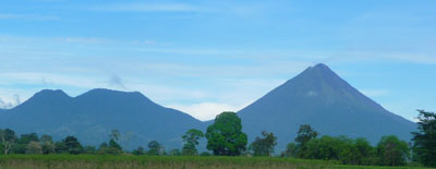
In the small town La Fortuna one of the many natural beauties it has to offer, the most  recognized attractions are Cerro Chato the creator of Arenal Volcano 


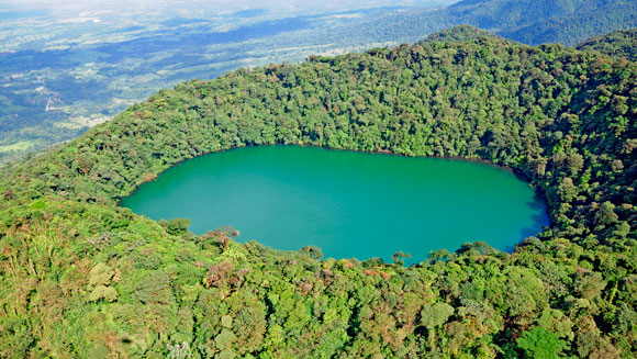
Cerro Chato also know as Chato Volcano is a dormant volcano next to Arenal Volcano that created the Arenal Volcano with explosions material and lava flows accumulated through eruptions. (1.Arenalnet) Cerro Chato height is 3,700 ft tall smaller than Arenal that is 5,437 ft tall. Cerro Chato has two peaks called Chatito, Espina and a crater that become a caldera with a lagoon.(2. Arenalnet)


Cerro Chato also help create another beauty of this small town La Fortuna Water Falls.(2)


Arenal volcano became active in 1968 when it had a big explosion destroying three small towns until October of 2010.(1) It’s a composite volcano/ stratovolcano that had explosive eruptions by having a very viscous lava, high amounts of gas under pressure, ash and pyroclastic material.(3) When I visited La Fortuna in 2006 for the whole week I was able to see the smoke coming out of the crater, hot fluorescent tephra flowing down its surface. When I was walking in the jungle I was able to presence an earthquake follow by a small eruption. From 2010 the volcano has been in resting phase not knowing when it will wake up.(2)

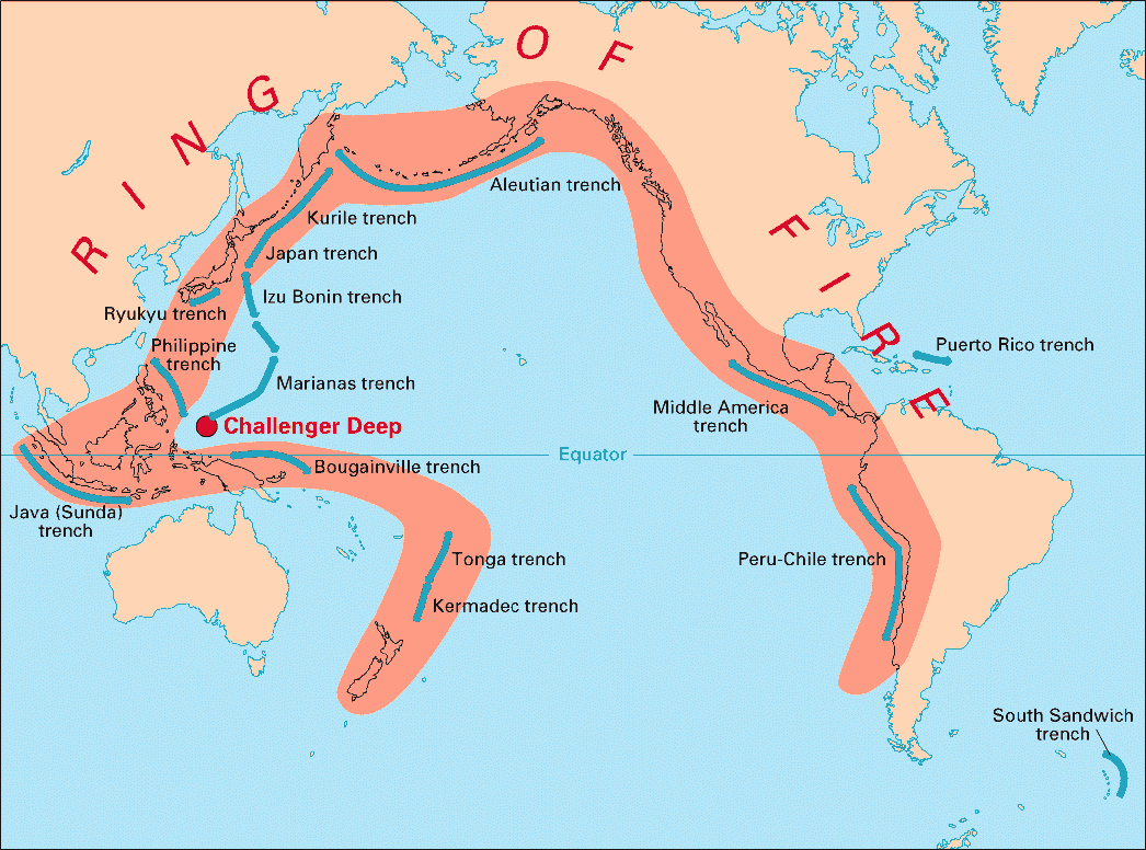
Arenal volcano is one of the youngest volcanoes that is part of the Ring Of Fire were most of stratovolcanoes are found located at convergent plate boundaries.(3)


Arenal Volcano is located between two oceanic and continental plates acting as convergent plates, the Cocos and Caribbean Plate.(3) Cocos plate moves under the Caribbean plate because is less dense going to the subduction zone. (4)At high pressures the material of Cocos plate is being recycled by melting to produce magma.


Sources
  1. Arenalnet (Arenal): http://www.arenal.net/arenal-volcano-overview.htm
  2. Arenalnet (Cerro Chato): http://www.arenal.net/tour/cerro-chato-hike/
  3. News and Information About Geology: http://geology.com/volcanoes/arenal/
  4. USGS (Convergent plate boundaries) : http://geomaps.wr.usgs.gov/parks/pltec/converge.html
  5. Image1: http://www.arenalvolcano.com/
  6. Image 2:http://www.arenalvolcano.com/Free_activities/cerro_chato.html
  7. Image 3: http://www.govisitcostarica.com/travelInfo/photoLg.asp?phID=952
  8. Image 4:http://www.costarica-nationalparks.com/arenalnationalpark.html
  9. Image 5:http://pubs.usgs.gov/gip/dynamic/fire.html
  10. Image 6:http://geology.com/volcanoes/arenal/

martes, 28 de agosto de 2012

Introduction


Hi my name is Issamar Pichardo, I was born in Chihuahua, Chihuahua Mexico migrated when I was eight years old. This last semester I finally choose my career Geography-Environmental Science after changing my major a couple of times. I am passionate about traveling, learning different cultures and discovering what nature has to offer that sometimes is taken for granted. At my young age I have been to Cuba, Costa Rica, Puerto Vallarta, Mexico City, Canada and hopefully this list continues growing.


The place I choose is a small town named La Fortuna located in Costa Rica, I traveled with my family when I was 16 years old, I was fascinating by the biodiversity in such a small town. My goal is to visit again La Fortuna but now understanding nature. The reason I choose this place is because the story of the small town is interesting, the owner of the hotel I stayed at told me the story of this small town named after a tragedy in 1968, Arenal volcano had a big eruption and earth quake destroying Tabacon and Pueblo Nuevo half of the original town and the other half was intact by the flow of lava that’s the reason why the small town was named La Fortuna translated to English as luck or fortune. La Fortuna has many attractions such as the Arenal Volcano, La Fortuna waterfall and hot springs. It was impressing to walk in the jungle close to the volcano and feel the movement in the floor when there were small eruptions. I am interest in learning more about how volcanoes are form, minerals the volcano provides to have a great biodiversity and how hot springs are heated by the volcano and said to be good waters to heal because of the minerals it contains.